Special Features
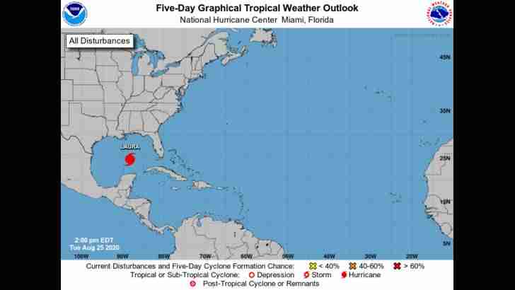
The center of Hurricane Laura at 25/1500 UTC is near 23.7N 87.0W, or 508 nm southeast of Lake Charles, Louisiana moving WNW
At 14 kt. The estimated minimum central pressure is 990 mb. The maximum sustained wind speeds are 65 kt with gusts to 80 knots. Satellite imagery shows that Laura is quickly becoming better organized as evident by a CDO feature that has developed over the center and large banding features in the SE semicircle of Laura. Numerous strong convection is near the center from 22N-25N between 85W-87W. Scattered moderate to isolated strong convection is elsewhere from 19N-25N between 84W-89W. A WNW motion should continue today. A turn toward the northwest is forecast by Wednesday, and a northwestward to north-northwestward motion should continue through Wednesday night. On the forecast track, the center of Laura will move across the southeastern Gulf of Mexico today. Laura is then forecast to move over the central and northwestern Gulf of Mexico tonight and Wednesday, approach the Upper Texas and Southwest Louisiana coasts on Wednesday night and move inland near those area on Thursday. Significant strengthening is forecast during the next 36 hours, and Laura is expected to be a major hurricane at landfall. Please read the latest NHC Public Advisory at https://www.nhc.noaa.gov/text/MIATCPAT3.shtml and Forecast/ Advisory at https://www.nhc.noaa.gov/text/MIATCMAT3.shtml, for more details.
A tight surface pressure gradient over the Canary Islands supports gale-force winds over the Canary Islands regional waters. The Meteo-France forecast consists of a gale warning in the area of CANARIAS. Please refer to the Meteo-France High Seas Forecast, that is listed on the website: www.meteofrance.com/previsions-meteo-marine/bulletin/grandlarge/ metarea2, for more details.
..Tropical Waves
A far eastern Atlantic tropical wave has its axis along 27W from 02N to 20N, moving westward at 10-15 knots. Scattered moderate convection is from 04N-10N between 22W-30W.
A central Atlantic tropical wave has its axis along 48W from 02N to 18N, moving westward at about 17 kt. This wave remains within a rather dry and stable environment. Only scattered showers are within 60 nm of the axis from 07N to 09N.
A trough is analyzed from near 24N66W to the E tip of Hispaniola near 18N68W. Scattered showers are within 120 nm W of the trough axis.
The northern portion of an eastern Pacific tropical wave along 88W extends northward to El Salvador and W Honduras, while the eastern Pacific monsoon trough extends from El Salvador east-southeastward across central Nicaragua and continues to NW Colombia. Scattered showers and thunderstorms that were over S Nicaragua.
Monsoon Trough/ITCZ
The monsoon trough axis passes through the northernmost coastal sections of Mauritania to 11N30W to 09N45W. The ITCZ extends from 08N50W to the coast of Venezuela near 09N60W. Aside from the convection related to the tropical waves, only scattered moderate convection is along the coast of W Africa from 07N-10N between 13W-18W.
Gulf Of Mexico
Please see Special features section above for details on Hurricane Laura.
Outside of Laura, the post-tropical/remnant low of Marco is near 29N92W with a pressure of 1010 mb and moving westward at 7 kt. The low is losing its identity with time and will soon transition to a trough as it continues westward for the next 24 hours. Scattered showers are near the low. Elsewhere, a surface trough is producing scattered moderate convection near Tampico Mexico from 18N-24N between 95W-98W.
Hurricane Laura is centered north of the Yucatan Channel near 23.7N 87.0W at 1500 UTC moving W-NW or 290 deg at 14 kt. Maximum sustained winds 65 kt gusts 80 kt. Laura will continue to gradually intensify as it reaches near 24.6N 89.2W early tonight, reaches near 26.0N 91.5W Wed morning with maximum sustained winds 90 kt gusts 110 kt, and continue over the NW Gulf to near 28.0N 93.3W early Wed night with maximum sustained winds 100 kt gusts 120 kt. Laura is then expected to move more northward and inland late Wed night through early Thu morning and reach near 30.5N 93.9W Thu morning. Laura will then weaken quickly as it moves northward and well inland Thu and Thu night. Expect long-period swell from Laura to impact most of the basin through Thu. Atlantic high pressure will build westward over the eastern Gulf in the wake of Laura.
Caribbean Sea
Scattered moderate to isolated strong convection due to Hurricane Laura is over the Yucatan Channel N of 19N. See above.
A tropical wave has moved inland over Central America with axis along 88W. See above.
A 1008 mb low is centered over N Colombia near 10N75W. Scattered moderate to isolated strong convection is S of 13N between 75W-84W.
Atlantic Ocean
An upper-level trough extends north-northeast from an upper low that is over the central Caribbean to near 25N70W. The northern section of an eastern Caribbean Sea trough extends to near 24N61W. Scattered showers and thunderstorms are quickly moving westward south of 24N between 65W-73W. Isolated showers and thunderstorms are elsewhere south of 27N and 78W.
A surface trough is N of Hispaniola. See above. Elsewhere, the tail-end of a central Atlantic cold front reaches to near 30N59W. Scattered showers and thunderstorms are noted north of 30N east of the front to near 50W. This activity is moving ESE. A 1021 mb high center is over the E Atlantic near 31N34W. Broad high pressure ridging is N of 23N.
Over the W Atlantic, high pressure north of the area will gradually shift southward through the rest of this week and into Sat. Fresh to strong southeast winds E of the Lesser Antilles will diminish to mainly moderate speeds on Tue.
Posted 4 hours ago by NHC Forecaster Formosa